The Belgian coast is centrally located in the European core area, at the southern tip of the North Sea. The limited surface area, combined with a wide variety of uses and activities, results in a complex interweaving of functions. The coastline itself is approximately 65 km long. It consists of wide sandy beaches to which a narrow dune belt usually joins. Many parts of this dune belt, which used to be contiguous, are fragmented. Inland stretches a flat and wide polder landscape. Seaward, on the shallow continental shelf, one finds a complex system of sandbanks and gullies.
On this page you will find a brief explanation of the ways in which the coast can be defined, as well as the powers that apply.
DefinitiON "THE COAST"
"The Coast" - Coastal Portal
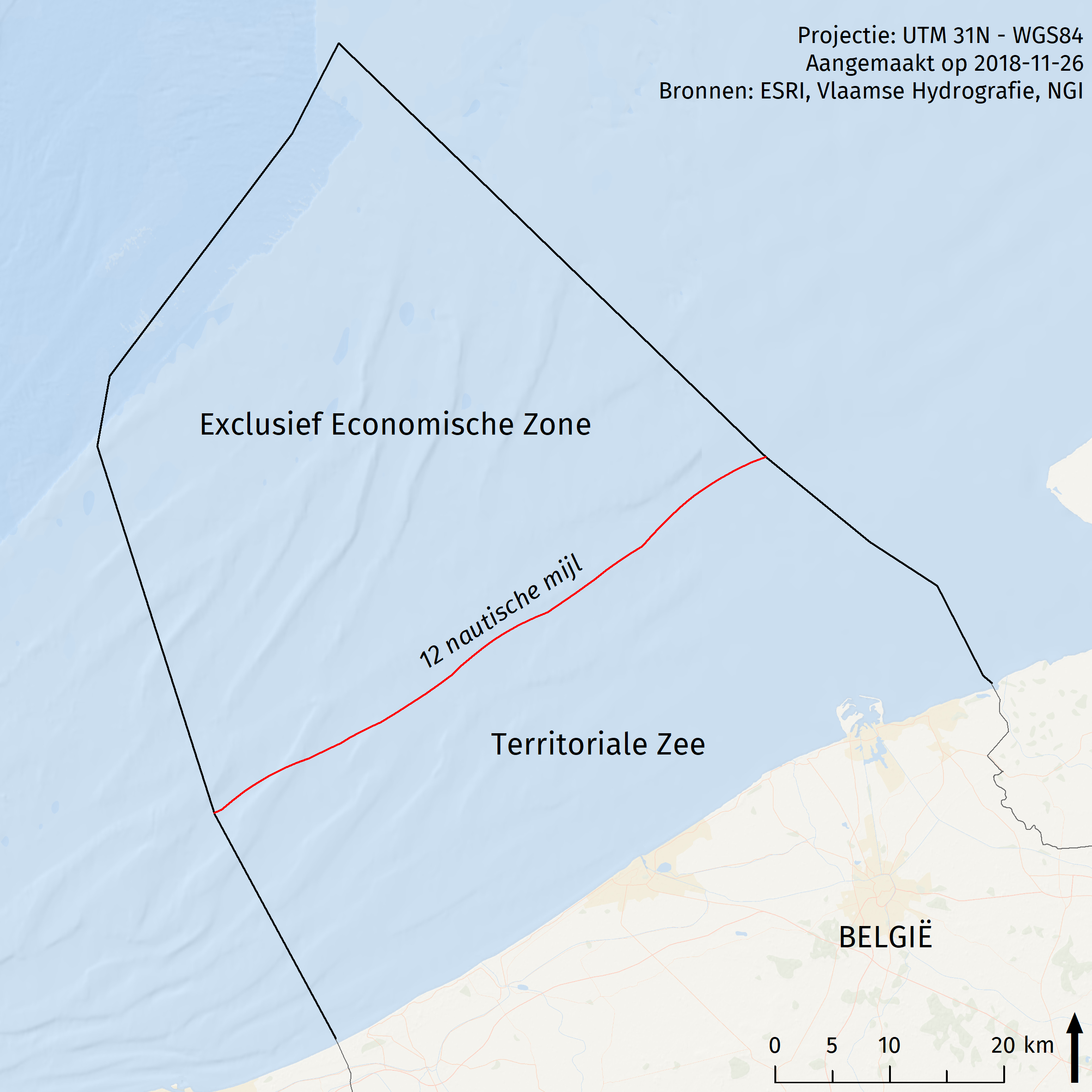
The term "Coast" can be defined in different ways, depending on the angle of view. Within the Coastal Portal, it is defined as the combination of the inland coastal plain and the Belgian part of the North Sea (BNS), with the coastline as the boundary between the two.
The BNS has a surface area of 3,454 km² and reaches at its furthest point about 87 km in the sea. The BNS is legally divided into the Territorial Sea (up to 12 nautical miles (NM) seaward of the baseline) and the Exclusive Economic Zone (EEZ, from 12 NM onwards seaward) according to the 1982 UN Convention on the Law of the Sea (UNCLOS). Within these respective zones, different powers, rights and obligations apply (e.g. Maes et al. 2013). The boundaries of the BNS, which touch the French, Dutch and British part of the North Sea, were drawn on the basis of the 11 pairs of coordinates below.
| Latitude | Longitude |
| 02°32'32"E | 51°05'34"N |
| 02°23'20"E | 51°16'06"N |
| 02°14'13"E | 51°33'25"N |
| 02°15'07"E | 51°36'44"N |
| 02°28'49"E | 51°48'15"N |
| 02°32'17"E | 51°52'31"N |
| 03°04'48"E | 51°33'03"N |
| 03°12'39"E | 51°29'02"N |
| 03°17'42"E | 51°26'57"N |
| 03°21'09"E | 51°22'43"N |
| 03°21'48"E | 51°22'22"N |
On the other side of the coastline is the Belgian coastal plain, about 65 km long and 10 to 20 km wide. It includes the territory of the following 10 coastal municipalities and 9 hinterland municipalities.
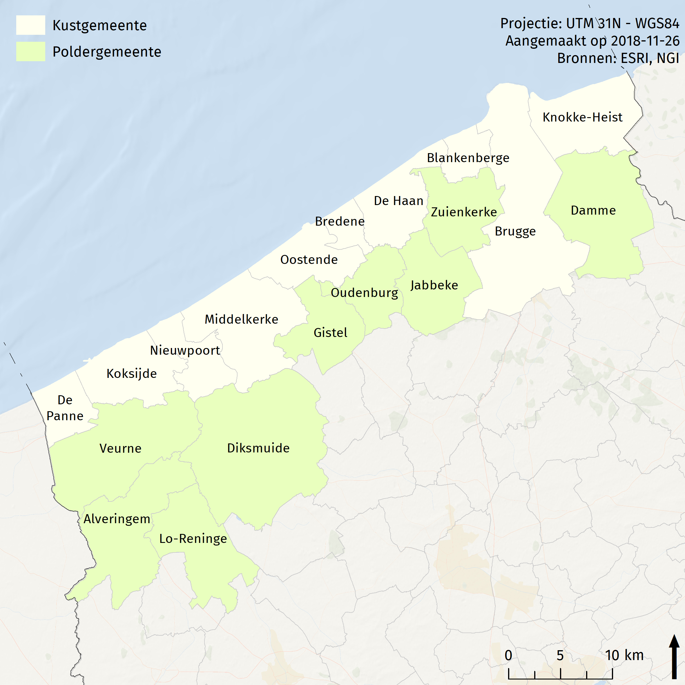
| Coastal municipalities | Polder municipalities |
| De Panne | Veurne |
| Koksijde | Alveringem |
| Nieuwpoort | Lo-Reninge |
| Middelkerke | Diksmuide |
| Ostend | Gistel |
| Bredene | Oudenburg |
| De Haan | Jabbeke |
| Blankenberge | Zuienkerke |
| Bruges | Damme |
| Knokke-Heist |
Please note that despite the above definition used by the Coastal Portal, the data found in this portal is not only limited to these zones. Themes such as 'Agriculture' and 'Nature Conservation and Environmental Impact' often contain map layers that visualise data on the landward side. The theme 'Maritime transport and ports' focuses on the seaports, which also include Antwerp and Ghent. In addition, there are various other interpretations of the term "the Coast", which are used elsewhere.
| Definition "The Coast" | |
| Classic | The strip of land and sea of varying width, which consists of that part of the land affected by its proximity to the sea, and that part of the sea affected by its proximity to the land, and the natural coastal systems and the areas where human activities involve the use of coastal resources (source: Duurzaamheidsbarometer, CDK). |
| Ecological | The ecologically functionally coherent area, consisting of the marine environment, beach, mud flats and salt marshes, the dunes and the polder areas. (source: Provoost & Hoffman, 1996). |
| Geological |
The maritime plain, which was created after the last ice age, consists of beach, dunes and polders.
|
Authorities
In general, it can be said that the federal authority is competent for activities carried out on the seaward side of the baseline, particularly in the territorial sea, the EEZ and the continental shelf, at least in so far as there are national sovereign rights in the latter areas (see UNCLOS). There are, however, a number of exceptions to this rule. The law of 8 August 1988 amending the special law of 8 August 1980 reforming the institutions gives Flanders the power to carry out the works and activities necessary for the exercise of these powers in the territorial waters and on the continental shelf (see table) (e.g. Maes et al. 2013, Pecceu et al. 2016). The province of West Flanders and the local municipalities also play their role, especially on the land side, within the hierarchy of competences (i.e. the principle of subsidiarity). The competences of each policy level are briefly discussed below for both the sea and the landward side of the coastline.
| SEA | LAND | |
| Federal Government |
|
|
| Flemish Region |
|
|
| Province of West Flanders |
|
|
| Coastal municipalities |
|
|